All hiking maps can be printed or downloaded as a PDF for your mobile phone for free:
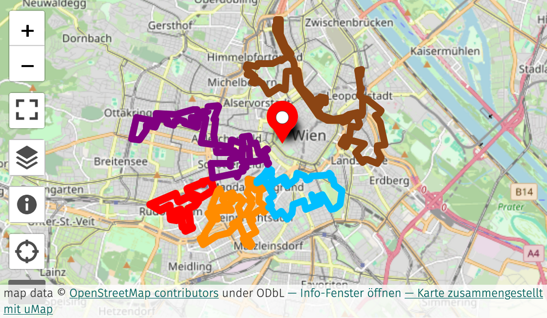
StreetArt Hiking Trail 1 ⬤
WESTBAHNHOF - 1150 - WESTBAHNHOF
Starting point / end point: 1150, Wien Westbahnhof, Europaplatz 2/3
Length: 6,8 km
Duration on foot: approx. 2h
Route: This hiking trail leads from the Westbahnhof (Train Station) via outer Mariahilfer Straße into hidden little alleys around the train station and railway area, via Schwendergasse and Reindorfgasse, Braunhirschenpark, Schwendermarkt, past the Technical Museum and Auer von Welsbach Park, onto Felber Straße, Rustensteg, Schmelzbrücke and back to the starting point of the city hiking trail. Along the way you will come across street art works by aldo giannotti, miquel wert, friend, linda steiner, the improper walls gallery, murals by thiago goms, nita., hnrx, sebastian schager (artis.love), a Wiener Wand legal wall, artworks by perkup, janosch feiertag, vera primavera, fitz licuado, deadbeat hero, moiz, emanuel jesse, jacoba niepoort, cyrcle. and gaia.
Significant places:- Westbahnhof
- Reindorfgasse
- Braunhirschenpark
- Schwendermarkt
- Rustensteg
The routes are not signposted - either take our Street Art Guide book with you or follow the PDF maps - in print or on your mobile phone.
StreetArt Hiking Trail 2 ⬤
WESTBAHNHOF - 1060, 1120, 1050, 1060 - WESTBAHNHOF
Starting point / end point: 1060, Wien Westbahnhof, Christian-Broda-Platz
Length: 13 Kilometer
Duration on foot: approx. 4h
Route: This walking trail leads from the Westbahnhof along the Gürtel to various works that adorn the Gürtel arches at the height of the U6 Gumpendorfer Straße, past Wiener Wände (legal walls), via the Längenfeldgasse skate park to the 12th district (Meidling). The route continues through the 5th district with oversized works by local artists ruin, perkup, friend and ripoff crew, to a colourfully designed school by el jerrino, a work by artist siuz, past various works by emanuel jesse, nils rva, paola delfin, jessica sabogal, via Margaretenplatz past the Rüdigerhof to the Falco Stiege (named after the famous Austrian musician), via the Naschmarkt parking lot back to the 6th district with monumental works by evoca1, stinkfish, ruin, helmut kand und die mauersegler, roa, around the flak tower of the Haus des Meeres, through Hofmühlgasse, Mollardgasse, Gumpendorfer Straße, past the rabbit eye movement, through various colourfully decorated alleys of Mariahilf, back to the starting point.
Significant places:
- Westbahnhof
- Gürtelbögen Gumpendorfer Straße
- Skatepark / Urban Gardening Längenfeldgasse
- Ernst-Lichtblau-Park
- Siebenbrunnenplatz
- Margaretenplatz
- Falcostiege
- Haus des Meeres
- Wienzeile
- Arik-Brauer-Haus
The routes are not signposted - either take our Street Art Guide book with you or follow the PDF maps - in print or on your mobile phone.
StreetArt Hiking Trail 3 ⬤
KETTENBRÜCKENGASSE - 1060, 1040, 1030, 1040, 1050 - KETTENBRÜCKENGASSE
Starting point / end point: 1050, U4 Kettenbrückengasse
Length: 10 Kilometer
Duration on foot: approx. 3h
Route: From Naschmarkt / U4 Kettenbrückengasse we walk into the 6th district, via Luftbadgasse past the Haus des Meeres (Aqua Terra Zoo) into Windmühlgasse, up and down three beautiful staircases via Stiegengasse and Capistranstiege, which were colourfully designed by several artists just off Mariahilfer Straße as part of the calle libre festival for urban aesthetics. We continue via Theobaldgasse and Fillgraderstiege past the Naschmarkt market stalls, past art nouveau buildings, restaurants, bars and past works by nychos, matheus bailon, gripface, dede and nitzan mintz. We continue our walk into the Freihausviertel quarter via the streets Schikanedergasse and Freihausgasse, with great views of famous monuments Secession, St. Stephen's Cathedral and the Opera, we walk across Karlsplatz, past the Vienna University of Technology, Karlskirche, Schwarzenbergplatz with its huge fountain briefly into the 3rd district to see a work by artez, continuing via the Botanical Garden and Belvedere Palace through the embassy quarter and get to see artworks by golif, sam3, daleast, el pez, alexis diaz. Heading onto Favoritenstraße and Wiedner Hauptstraße to see murals by kobra and kruella, d'enfer, we finally get back to the starting point.
Significant places:
- Naschmarkt
- Stiegengasse, Capistranstiege, Fillgraderstiege
- Theobaldgasse
- Freihausviertel, Schikanedergasse, Freihausgasse
- Karlsplatz
- Schwarzenbergplatz
- Botanischer Garten
- Schloss Belvedere
- Botschaftsviertel Prinz-Eugen-Straße, Argentinierstraße, Theresianumgasse
- Wiedner Hauptstraße
The routes are not signposted - either take our Street Art Guide book with you or follow the PDF maps - in print or on your mobile phone.
StreetArt Hiking Trail 4 ⬤
VOLKSTHEATER - 1070, 1080, 1160, 1070 - VOLKSTHEATER
Starting point / end point: 1070, Arthur-Schnitzler-Platz 1
Length: 17,2 Kilometer
Duration on foot: approx. 5h - or walk it in several parts ;)
Route: From the Volkstheater subway station (U2/U3) we turn into Burggasse and Kirchberggasse to see an artwork by huariu. Further north into Gardegasse and then into the 8th district Josefstadt we cross an artwork by boicut. Continue westwards through the alleys and across the Gürtel to the 16th district (Ottakring). Continue into Koppstraße, to Brunnenmarkt and get to see Vienna's probably most diverse market and a huge mural by bezt - etam cru. We continue past Garage Grande (a former car parking garage now used by artists and urbanist collectives) and get to see the Ottakringer brewery. Just around the corner is the art hotspot die schöne with many murals on the walls. Let's hike westwards to Paltaufgasse to an artwork by fabio petani, along the U3 Ottakring underground station back again via Thaliastraße and Ottakringer Straße to Yppenplatz, where street art, market stalls, multicultural life, bars and gastronomy complement each other wonderfully. Continue along Gürtel past a work of art by golif, back along Kaiserstraße and Josef-Strauß-Park with a mural by frau isa, into Burggasse with the street art hotspot Burggasse 98 and Karl-Farkas-Park, along Westbahnstraße to saddo in the inner courtyard of WestLicht, Museum of Photography and Photo Art, across Urban-Loritz-Platz, via the many hip alleys of the 7th district - Neubaugasse, Kirchengasse, Siebensterngasse, Breite Gasse and the Street Art Passage of the MQ (Museumsquartier), with a bridge designed by space invader, and back to the Volkstheater metro station.
Significant places:
- Volkstheater
- Burggasse
- Brunnenmarkt
- Ottakringer Brauerei
- Die Schöne
- Yppenplatz
- Kaiserstraße
- WestLicht.
- Neubaugasse, Kirchengasse
- Museumsquartier, Street Art Passage
The routes are not signposted - either take our Street Art Guide book with you or follow the PDF maps - in print or on your mobile phone.
StreetArt Hiking Trail 5 ⬤
LANDSTRASSE, WIEN MITTE - 1030, 1020, Donaukanal, 1090, 1200, 1090, 1010, 1030 - LANDSTRASSE, WIEN MITTE
Starting point / end point: 1030, Landstraßer Hauptstraße 1c
Length: 21,3 Kilometer
Duration on foot: approx. 6:30h - or walk it in several parts ;)
Route: This circular hiking trail starts at Landstraße / Wien Mitte - The Mall subway station. From here you walk around the complex through the alleys of the 3rd district to Rochusmarkt, across Wassergasse to Donaukanal, across Rotundenbrücke to Böcklinstraße, a street which runs parallel to the Prater park and that is home to countless Art Nouveau and Gründerzeit style buildings. Past magdas hotel on Prater Hauptallee, past the fluc club across Praterstern into the 2nd district, to the student hotel with artworks by david shillinglaw and lost.optics, then back to the Danube Canal at Franzensbrücke bridge to Salztorbrücke bridge with countless murals. Once again into Leopoldstadt (2nd district), to Ludwig-Hirsch-Platz with a work by zesar bahamonte and a typeface wall right next to it. Past architecturally striking buildings across Karmelitermarkt and back to Salztorbrücke down to the banks of the Danube Canal. Upstream you will find countless constantly changing works of art until you get to the Rossauer Brücke bridge. At the Siemens-Nixdorf-Steg footbridge we change to the other side, stroll through the Servitenviertel (9th district), past the Bergasse, through the Arne-Carlsson-Park, past modern architecture and make a detour to the inner courtyard of the WUK arts and culture centre. Back down to the Danube Canal at the Friedensbrücke bridge. Upstream in direction of Spittelau we find a building by Zaha-Hadid with some impressive adorning artworks and in close vicinity the famous electronic / techno music venues theWERK and grelle forelle with artworks on all sides of the buildings. There you'll see some large-format murals by case maclaim, roa and nychos, among others. Parallel to the 20th district Brigittenau, the route continues back downstream, at the Friedensbrücke bridge we cross sides again to the right downstream river canal bank and continue downstream past Rossauer Lände, Schottenring, flex music venue, past the floating gardens of Kaiserbadschleuse, to Urania - crossing the small bridge of the Wienfluss river and the Donaukanal past the beach bar Strandbar Herrmann. In front of Franzensbrücke bridge we walk through the pedestrian tunnel into the 3rd district, into Löwengasse, via Radetzkyplatz, Obere Zollamtgasse back to Wien Mitte, where we started.
Significant places:
- Landstraße, Wien Mitte
- Rochusmarkt
- Böcklinstraße
- Prater Hauptallee
- Donaukanal
- Karmelitermarkt, Ludwig-Hirsch-Platz
- Servitenviertel
- WUK
- Friedensbrücke
- Spittelau
- Schottenring
- Urania
- Radetzkyplatz
The routes are not signposted - either take our Street Art Guide book with you or follow the PDF maps - in print or on your mobile phone.
All hiking maps can be printed or downloaded as a PDF for your mobile phone for free:
All hiking trails start at prominent locations in Vienna and are easily accessible by public transport. They can be started either at the beginning or the end of the route, the direction is not predefined. Of course, the walking routes can be walked in several parts. Some routes are very demanding in terms of distance! Use of public transport is recommended.It is recommended to follow the marked routes as closely as possible in order to see as many street art works as possible.
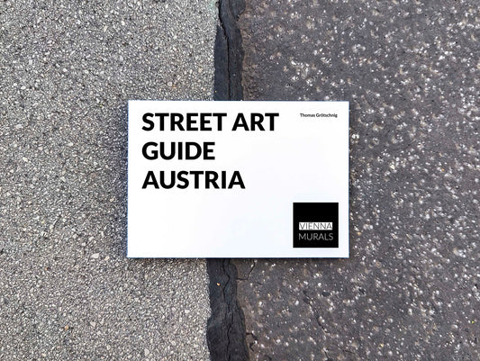
Discover murals all over Austria with the book 'Street Art Guide Austria':


Use of the suggested routes at your own risk.
The routes are not signposted - either take our Street Art Guide book with you or follow the PDF maps - in print or on your mobile phone.
It is strongly advised to cross roads only on pedestrian crossings and to watch out for traffic at all times. Enter courtyards and private property only if permitted.
Routes are primarily aimed at pedestrians - take care with bicycles in city traffic and use bike lanes when possible.
Please always follow current hygiene measures and keep your distance from other people.
The author is not responsible for content, accuracy or completeness.
There is no connection whatsoever between these routes / footpaths and official footpaths of the city/state/federation or any other institutions.